Monday, 25 February 2013

Manchester Ramble 2

Route as last weekend
Weather: light snow most of Saturday and later on Sunday
Seen: fancy ducks (teal?), one 'kin huge dead fish, cormorant, baby lambs, Cloud Atlas

Sunday, 17 February 2013

Manchester Ramble

Distance: 35000 + 37500 steps (mine)
Ascent: 80 + 120 staircases
Weather: cold but sunny
Seen: wren, pied wagtails, Die Hard

We needed some long training walks in preparation for our upcoming week in the mountains and, having various vouchers due to expire and birthday money burning a hole in my pocket, decided to walk in and back out of Manchester over the weekend.

We went in roughly following the route of the Medlock Valley Way - which we have ammended over the years to avoid various muddy spots - and came back along the Rochdale Canal and Oldham Way.

Saturday, 2 February 2013

Gavel Pike

Distance:
Ascent:
Weather: blue sky, sunshine, cold, bitter wind
Seen: icicles, snow, spectacular views

From Glenridding, we walked through the village and along to Deepdale. The valley feels remote, surrounded by steep sides and snowy tops. At the end of the valley, we went up to Sleet Cove and then up to Deepdale Hause. It looked as though it would be easier heading up to the left side, but as we got nearer to the head of the valley the way straight up didn't seem as bad as we'd thought. We stopped part way up to put our spikes on our boots, which helped a lot on the steeper bits and snowy patches. It was still a relief to get to the top!

We headed over the top of St Sunday Crag and the down through the icy snow to Gavel Pike. We were followed by a couple who didn't have any spikes or crampons, heading down over the steep icy snow, they'd fallen over a couple of times near the top and it was rather nerve-wracking watching them, but they made it down ok. Crossing the snowier patches was interesting, and it was very cold and windy. We stopped for a brief lunch stop, and stopped for a longer time for tea and biscuits when we were down a bit out of the wind, back in the sunshine.

The path was clear and easy back down to the valley, where we were overtaken by a couple who appear to just jump off a crag and then bounce down the path into the distance. We were in no rush...

Back to the hotel, for beer and crisps.

Heron Pike

Distance: about 7 miles
Acent:
Weather: cool, cloudy with occasional sunshine, dry
Seen: kestrel, bit of blue sky

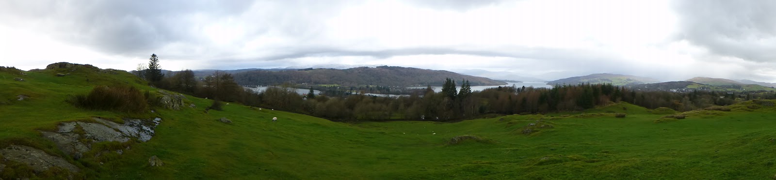
After a big birthday breakfast and opening of presents , we set off up through Glenridding village and up the Rake to Heron Pike. The path was pretty steep and my big boots pretty heavy, but we made it ok. From there we headed up to Sheffield Pike and at the top had lunch with hot tea under blue sky, in the sunshine. There was a bit of snow on the ground, untrodden, so we went around it as much as possible.

Coming down we had fine views over Ullwater with a rainbow and we followed the lakeside path back to Glenridding. We had to wait a little while at one point as there was tree felling, but when way was cleared we were able to join the path again avoiding the road.

We added a short additional walk up to Lanty's Tarn, and then back from Patterdale to Glenridding.

We were back at the hotel in time for  birthday tea and scones. Yay!

Sunday, 25 November 2012

Gummer's How

Distance: 9 miles
Ascent: 500m
Weather: Dry but cloudy and chilly (5°C)
Encounters: Fox, hounds, bogs, jays, moonrise

We parked at the car park near to Fell Foot and got all wrapped up before heading off up the path towards Sow How Lane. A fox headed off in the other direction. There were quite a lot of hounds hurrying about, not letting little things like gates get in their way. Turning off the lane, we went along a forestry track for a bit and then had a wander about in the stumpy, wet forestry plantation to visit a top that doesn't seem to have a name.

After short respite of track (with photograph-taking services) and we were off again up through undergrowth and heather to the top of Swainson, which is one of Wainwright's Outlying Fells and has good views over Windermere. The return back to the track was easier after crossing over the wall.

Sadly missing out the wonderfully named Cop O'Cow Hill which is wooded and looked well fenced in, we walked around Simpsons Reservoir and followed Way Beck (in full spate) north and along a wall through (wet) woods. There was a lot of wet. Quite a lot of it went into Rob's boots.


We passed near Sow How Tarn and through the well manicured looking park land  passed Heights Cottage. The return took in Gummer's How, where Rob took in additional top of Birch Fell and I got some cow-y water in my boot and decided against crossing the muddy stream. So I stood around in some cow-y gorse admiring the views and watching the moonrise.


Saturday, 24 November 2012

Wintry Day on the Dalesway

Distance: 10 miles
Ascent: 450m
Weather: grey and nippy
Seen: mud, water bubbling up from the ground, off-limits hill, swans.

We retraced our steps into Bowness and headed off again along the Dalesway. Where yesterday we turned off at the first crossroads, today we carried on along a very pretty path, muddy in places to School Knott promontory and Grandsire. We walked on, through a very wet field with water bubbling up, swirling around in a hollow and disappearing back into a culvert or something. The water was splashed through, slippy rocks and tree stumps almost avoided. We stopped by a fence and looked over to a 256m Hump and decided it was too far from the right of way to visit.
We retraced our steps back to where the path splits between Bowness and Windermere (near Heathwaite Manor) and took the north route back to Windermere.


Friday, 23 November 2012

Bimble around Bowness

Distance:
Ascent:
Weather: started off fine with blue skies, then grey skies, rain, pub.

We walked from our hotel in Windermere along the road to Adelade Hill and then followed the shoreline of Windermere as far as possible (not far) and back to the road through a very soggy but passable field.

A look around the shops (and tearooms) of Bowness and we wandered off up the Dalesway for a short way, before turning off up to Brant Fell. Just as we were considering potential lunch spots, the rain came in and stayed for a few hours. So we went back into Bowness (and pubs) Robinson's Tom and Berry is especially recommended.