Sunday 25 November 2012

Gummer's How

Distance: 9 miles
Ascent: 500m
Weather: Dry but cloudy and chilly (5°C)
Encounters: Fox, hounds, bogs, jays, moonrise

We parked at the car park near to Fell Foot and got all wrapped up before heading off up the path towards Sow How Lane. A fox headed off in the other direction. There were quite a lot of hounds hurrying about, not letting little things like gates get in their way. Turning off the lane, we went along a forestry track for a bit and then had a wander about in the stumpy, wet forestry plantation to visit a top that doesn't seem to have a name.

After short respite of track (with photograph-taking services) and we were off again up through undergrowth and heather to the top of Swainson, which is one of Wainwright's Outlying Fells and has good views over Windermere. The return back to the track was easier after crossing over the wall.

Sadly missing out the wonderfully named Cop O'Cow Hill which is wooded and looked well fenced in, we walked around Simpsons Reservoir and followed Way Beck (in full spate) north and along a wall through (wet) woods. There was a lot of wet. Quite a lot of it went into Rob's boots.


We passed near Sow How Tarn and through the well manicured looking park land  passed Heights Cottage. The return took in Gummer's How, where Rob took in additional top of Birch Fell and I got some cow-y water in my boot and decided against crossing the muddy stream. So I stood around in some cow-y gorse admiring the views and watching the moonrise.


Saturday 24 November 2012

Wintry Day on the Dalesway

Distance: 10 miles
Ascent: 450m
Weather: grey and nippy
Seen: mud, water bubbling up from the ground, off-limits hill, swans.

We retraced our steps into Bowness and headed off again along the Dalesway. Where yesterday we turned off at the first crossroads, today we carried on along a very pretty path, muddy in places to School Knott promontory and Grandsire. We walked on, through a very wet field with water bubbling up, swirling around in a hollow and disappearing back into a culvert or something. The water was splashed through, slippy rocks and tree stumps almost avoided. We stopped by a fence and looked over to a 256m Hump and decided it was too far from the right of way to visit.
We retraced our steps back to where the path splits between Bowness and Windermere (near Heathwaite Manor) and took the north route back to Windermere.


Friday 23 November 2012

Bimble around Bowness

Distance:
Ascent:
Weather: started off fine with blue skies, then grey skies, rain, pub.

We walked from our hotel in Windermere along the road to Adelade Hill and then followed the shoreline of Windermere as far as possible (not far) and back to the road through a very soggy but passable field.

A look around the shops (and tearooms) of Bowness and we wandered off up the Dalesway for a short way, before turning off up to Brant Fell. Just as we were considering potential lunch spots, the rain came in and stayed for a few hours. So we went back into Bowness (and pubs) Robinson's Tom and Berry is especially recommended.


Sunday 28 October 2012

Sheep in the City


 This is an itinerary of our trip to London 20-27th October 2012 (so when the minds start to go we have a record, assuming the internet is still functioning by then of course).

Saturday

Arrived

Dinner - Indian meal in Warwick Arms (we called in here for quite a few beers in the evenings, almost became our local for the week)

Sunday

Collected London Pass tickets
London Transport Museum (included in London Pass, otherwise we would have ignored - turned out to be really good ;) )
Globe Theatre
Old Operating Theatre Museum and Herb Garret
Millennium Bridge (walked across)
British Museum (at the end of a long day - more a flying visit - to see the mummified cat...)
Rock Of Ages musical show

Dinner - The Old Crown Inn

Monday

Tower Of London
Tower Bridge Experience
Trip on DLR to
Cutty Sark
Greenwich Observatory and Planetarium
Thames Cruise back to centre

Dinner - Italian in Kensington

Tuesday

Kensington Palace (disappointingly 'modern' style of museum)
Walked via Kensington Gardens, Hyde Park, Green Park, St James's Park
Churchill War Rooms
Westminster Abbey
Mystery of Charles Dickens (Simon Callow one man show)

Dinner - 'Pub' (The Bear & Staff?) in Leicester Square

Wednesday

London Zoo
Science Museum

Dinner - Hansom Cab in Kensington

Thursday

Lords cricket ground tour
Kew Gardens

Dinner - Brysons (burger restaurant) in Kensington

Friday

Hampton Court Palace

Dinner - Tesco Finest meal :)


Saturday 22 September 2012

Matterdale Common and Dodds

Distance: 11.5 miles
Ascent: approx 900m
Weather: chilly start, sunny.
Going: soft, soft to bog

We parked at the car park just south of Dockray and walked up through the village and along the lane to High Row. We followed the wide track for a while and then turned off on to a wet path through the grass (and bog, yay) up on to High Brow. Lots of swallows flitting about here. Bog abounded on the way to Randerside, where they were herding the sheep, and then we met the main path again which led us up to Great Dodd.

Little Dodd was next on our route, marked by a small pile of stones and some sheep, and then we contoured round a very wet path around onto Stybarrow Dodd. Here we met Billy the dog, who likes to stand in puddles, and a beardy American chap who liked to chat.

We had a fine lunch, with more tiffin and hot tea, on Stybarrow Dodd before heading over to White Stones (with the annoying drone of a microlight circling overhead), Hart Crag and Birkett Fell. From here we visited Brown Hills, Swainside Knott (with fine views over Ullswater), Common Fell (overtaken by hounds) and down on to Round How and Bracken How - where there was a lot of bracken and rabbit holes.

The path then follows the wall and looks to lead straight to the car park, but the walk had a little sting in its tail with a broken stile over the wall and a steep, rocky, muddy scramble down Brunt Crag. I had to sit on my coat in the car (again.)

From Randerside towards Derwent Water

 Top of White Stones
 see more photos

Route map and download gpx

Friday 21 September 2012

Under Place Fell

Distance: 12.5 miles
Ascent: approx 900m
Weather: mostly sunny, one shower
Paths that weren't: 1
Deer: 4
Caterpillars: wooly
Squirrel: 1 (colour undetermined, but hopefully red because of where it was)

We arrived in Patterdale and left the car in the hotel car park, where we are staying for the weekend. A track leads up to Side Farm (where we were passed by enthusiastic campers driving like idiots) and then we took the pretty (but popular) path up around the edge of Ullswater.

An attempt was made to follow a path up the side of Scalehow Beck, but it was lost in the bracken and steep rocky hillside.  We aborted and returned to the track, which was quite interesting (especially the clinging on to roots and tree branches while scrabbling for purchase) the ascend by the clear grassy path further along (this one marked on all the maps) before crossing the beck (a useful gravelly patch in the middle of the stream to jump to) and up on to Low Birk Fell. We had lunch here, with tea and chocolate tiffin from The Lunch Box in Ambleside.  Sheep trods led all over, and we followed them to Bleaberry Fell / Birk fell and up to The Knight, which has a pretty little ridge (making it look very pointy from a distance.) coming down, we passed a couple (he seemed to be having a good time, but his companion, not so much) and followed the wet grassy path back along to High Dodd (steep grassy descent) and Sleet Fell. There was a short sharp rain shower, so we had to put our waterproofs on, but it soon passed.

There aren't really any clear paths down from here, so we followed some streams and deer trods (complete with deer family) through the bracken, where it was least steep, back to the main path. We returned along the lake side path back to Patterdale, accompanied by midges, but rewarded by lovely views of the lake.


Scalehow Beck and Ullswater
Deer on Sleet Fell

 Route map and download gpx

Wednesday 19 September 2012

Yewdale and Tilberthwaite Fells

Distance: 10.5 miles
Ascent: about 800m
Weather:  sunshine and showers
Seen: heron, lots of sheep, tree that looked like it was growing out of a rock, but wasn't
Heard: Jetfighter very close by in next valley

The morning was spent doing washing and reading Swallows and Amazons by Arthur Ransome and getting valuable tips on sailing, for if/when we ever take up sailing... this will possibly just after I take up ghyll scrambling...

We took the disused railway line into Coniston and then the lane around to the Coppermines, the same as yesterday, but where we turned off (possibly too soon) yesterday, we carried on up today. Not far along Hole rake, to the surprise of the group of people coming the other way, we turned off up the grassy slope to Kitty Crag. From there, we went to Long Hill, High Wythow, Low Wythow and Brackeny Crag (not shown on the OS map) before dropping down to the path that leads to Tilberthwaite Gill and Yewdale Beck. The beck is crossed by a little footbridge, which was easier than the stepping stones over Crook Beck just beforehand. I made it eventually...

We followed the easy path around and then headed up the coll and up to the top of Blake Rigg, Haystacks, through the windswept trees and steep grass hillside (with plentiful sheep poo) up to Hawk Rigg, High Fell and Great Intake. We followed a path passed some mine workings and then down following the wall to the National Trust car park at Low Tilberthwaite. Here we had a bit of a sit on a bench, before following the lane down to the main road, where there is a lovely path through woodland that runs next to the road all the way back into Coniston.


Towards Langdale

Route map and download gpx

Tuesday 18 September 2012

Grey Friar and Dow Crag

Distance: 15 miles
Ascent: 1450m
Weather: sunshine and showers, strong wind
Wainwrights ticked off today: 2
Wainwrights climbed: ALL 214!
Things Seen: fighting kestrels, comedy bunnies, the Milky Way, the sea.

It was with heavy hearts bags that we started today's walk, to our last two unclimbed Wainwrights.

We followed the old railway line into Coniston and then the lane up towards the old Coppermines. Turning right, we headed up the path to Wetherlam, possibly too soon, as we ended up meeting the main path a little further up - but we do like a bit off off-path. Looking back there were clear views over Coniston and a flock of geese honking away as they headed south.

The wind was noticeably stronger the higher we went, and by the time we'd been over Wetherlam, Black Sails and up the Prison Band (delightfully rocky) to Swirl How, it was incredibly windy indeed, complemented by cold, hard, driving rain. We dropped down to a lower path (still wet and windy) passed the site of the 1940s plane crash and out towards Hell Gill Pike, where the rain briefly eased, and then contoured around to Grey Friar.

We returned the way we'd come, to meet a path that led underneath the Brim Fell (unfortunately still on the windy side, which made for some wobbly walking on the narrow path) and up to Dow Crag. At Goat's Hawse (sadly lacking in goats) we passed at least three people wearing shorts, which gives me a chill even thinking about it, as I was in thick Paramo trousers, waterproofs, fleece hat and Buffalo Mitts. The girl in green, wearing shorts, fleece and wooly scarf, made it about a third of the way up Dow Crags before turning back, her friend in wellies didn't even attempt it.

The wind was very strong, but then eased slightly at the top, where Rob visited the summit three times (I just went the once) and then we had celebratory Jaffa Cakes and Prosecco in the shelter. There were a few drops of rain, but the wind soon blew the clouds away and it was spectacular blue sky and clouds as we crossed Buck Pike and Brown Pike to meet the Walna Scar Road (with quick trip up to Walna Scar top) before following the road back down to Coniston (complete with rainbows.)

Our few pints and slap up dinner at The Sun Inn was excellent.

Dow Crag


Route map and download gpx


Monday 17 September 2012

Culture, Cake and Countryside around Coniston

Distance: about 10 miles
Ascent: about 500m
Weather: sun and showers (some heavy)
Trees sniffed: 3 (incense cedar, bay, noble fir)
Log fires sat in front of: 2

From our cottage, we took a path behind the Ship Inn up onto the dismantled railway line (which one could probably join earlier from the lane behind the catholic church) that takes you into Coniston.

We had a look around the Ruskin Museum, where gift aiding your entry gets you a year's free return visits - which we shall be making use of as we didn't quite have time to see the Ruskin exhibit before we left to catch the 10:45am sailing of the launch across to Brantwood, where Ruskin lived his last years.

The crossing was a little choppy at times and there were ominous clouds overhead, but the heavens didn't open until just after we'd disembarked and, being first off the boat, we were able to hurry up the garden path and into the cafe, to place our order for soup and sandwiches before the other bedraggled passengers arrived.

After lunch we toured the house, which was filled with lovely things, and the gardens, lots of zig zags, and followed the estate trail out onto a bridleway which leads through some pretty woodland onto the lane that leads to Monk Coniston arboretum. We were lured into the cafe and fed enormous pieces of cake and coffee before visiting the trees, one of which is one of the rarest trees in the world. The tree trail is free and a lot of fun, there is a great NT leaflet.

We walked up the footpath to Tarn Hows and then around the tarns and saw more Humbug cows and a buzzard in the trees.

We returned to Coniston via The Cumbria Way (in full waterproofs) stopping off in the Black Bull for dinner and Old Man Ale.


Route map (please take the boat) and download gpx


Saturday 15 September 2012

Harter Fell and Green Crag

Distance: about 10 miles
Ascent: about 900m
Weather: a little cloudy
Going: wet and boggy
Midges: thousands of 'em
Wainwrights: 2 down, 2 to go

We parked at the car park at Birks Bridge, which has parking for quite a few cars and crossed the new bridge on the forestry track. On the way, we'd seen a couple of deer and some Humbug cows (later identified as belted galloways.)

Leaving the track we turned right on to a wet rocky path heading north through Dunnerdale Forest. Most of the forest has been chopped down and stacked up by the side of the track, so it was more heathery moorland than woods, and the going was very muddy in places, especially the place I put my foot in up to my ankle.

We headed off the path straight over to Horsehow Crags (good views down over the Roman Fort), picking up a faint path that headed though the grass to a stile and up on to Demming Crag and then Harter Fell. There were some hounds out for a run today, their baying echoing eerily around the Fells. It was quite an unnerving feeling, even though I knew they weren't after us, being out of breath as we climbed up the steep grassy slopes of Harter Fell and having barking dogs closing in on us - the sort of memory that could one bad night be a sound basis for a nightmare.

We contoured around under Demming Crag, where we were briefly accompanied by a herdwick sheep, coming to the top from the other side and then made a push for Harter Fell. Here we stopped just behind the summit cairn for lunch and a flask of tea, while watching the cloud descend.

We left the top on the path that heads down ENE and then left that to contour across to cross Spothow Gill and up to Kepple Crag. We followed the line of the ridge up to Green Crag and then down via a sheep trod, which met up with a boggy path that headed through some bog to meet Grassguards Gill where we entered Hard Knott Forest (which we remember well from our North of England Way Walk) with its signs announcing the introduction of deciduous trees, natural habitats and bog, because everyone loves a bog. It was utterly bog-tastic today.

Emerging from the mire we found ourselves on a forestry track, where a couple of very posh lads asked us if by any chance we'd seen any sign of some hounds. Why yes, yes we have. They had been blowing their horn, but I don't think the beagles cared.

We followed the forestry track (accompanied by some very friendly midges) back down to the bridge and the car park.

 The top of Harter Fell

Route map and download gpx


Friday 14 September 2012

Hard Knott

Distance: 7 miles
Ascent: 600m
Weather: very windy,  with occasional sunshine and more than occasional wet
Hats lost: one
Bruised shins: two, matching (Rob's)
Wainwrights: 1 (4 left to do)

There is a very small car park right at the top of the Hardknott Pass, and we parked there to start our walk today. We came from Coniston, over the Wrynose Pass, and had some lovely views, it's much easier travelling over the hills by car, but not so easy to stop to take photos.

We headed up over Border End, where it soon became obvious quite how windy it was, on some of the tops we visited it was quite difficult to walk or even to stand, a couple of times we found ourselves sheltering behind rocks or sitting down unexpectedly (that was mostly me) and there was a terrible hat tragedy when Rob's merino beany disappeared into orbit.

The ground was very wet and there were a lot of bubbling streams and bogs to enjoy, lined with a lot of little yellow flowers (similar to Hawkseye), purple thistles and a couple of harebells.

From the summit of Hard Knott, we followed the grassy ridge north, to meet Lingcove Beck and come down a wet, rocky and occasionally very slippy path into the valley towards the pretty Lingcove Bridge and impressively watery Vicar Swa waterfall.

From here the path became better (although still wet) leading to the farm under Bell Stand, where we met the road again and headed up the pass to visit the Hardknott Castle Roman fort. We had a chat with a couple of women walkers who were camping in Eskdale valley, hopefully the site is sheltered - we reckon it must be gusting 60 to 70 mph winds today. The Roman fort is really big, with lots of walls left to walk around. I can't imagine what the Roman Centurians would have made of the north of England if today's weather was anything to go by.

From the fort we walked back up to the car, mostly off road. A few supplies bought at one of the stores in Coniston village and we are happily ensconced in our cottage. We had yummy pies and ale for dinner at the Ship Inn, which was nice but not especially comfortable.

River Esk

Route map and download gpx


Sunday 2 September 2012

Top Bagging around Haystacks and Fleetwith Pike

Distance: 6 miles
Ascent: about 600m
Weather: cloudy start, becoming warm and sunny
Brown feet: one (this time Helen's)
Annoying dogs: none
Quite annoying blokes: one

As we approach the completion of the Wainwrights, Rob has spent some time compiling lists of other hills that we can climb around the country - focusing, of course, on our favourite place, the Lake District. So we now have plenty reasons to go for a walk. Our new list is a compilation from www.hills-database.co.uk, and includes mainly Hueys, Deweys and Louies Marilyns, Birketts, Nuttalls, Hewitts, Deweys and HuMPs, plus County Tops and mysteriously named "Others".

Today's walk included four tops, some of which proved quite elusive - their grid references encouraging us to walk off edges into thin air (I think not) - and plenty of bimbling about looking at the sheep, views and fish in the tarns.

From the NT car park at Honister Hause, we took the Tramway Path to Drum House and up through the clag following the cairned path across to Loft Beck and up to Seavy Knotts, where the clouds cleared to reveal a lot more sheep in the vicinity than we'd thought. We visited some rocky tops along the ridge at Haystacks SE Top, towards Innominate Tarn, down a good rocky path to Blackbeck Tarn (with fish) and over Green Crag.

There were clear views now, although we noticed (a little bit relieved that we weren't missing out) that Pillar was still capped in cloud.

We scrambled back down to the main path, passed a lady who was very determined to not get her boots wet. I splashed through, taking the opportunity to rinse my boots having had a wobbly rock / mud incident a few minutes previously. I did keep out of the water as we crossed over the next beck at the stepping stones and up the hill direct to Honister Crag, Black Star, where we had a bit of a sit. From here we took the quarry vehicle track back down to the mine, and had some lunch in the cafe - where we were joined by a dog which just stood there minding its own business until some bloke came up and said to just ignore it, then proceeded to tell us a (not very) funny story about him. The dog didn't say anything.


Saturday 1 September 2012

Pillar

Wainwrights: one!
Distance: 11.5 miles
Ascent: 1200m
Weather: cloudy in morning, clearing and windy in afternoon
Hat incidents: one
Flappage: a lot

We are staying at the YHA at Honister Pass, which is basic but convenient for this week's attempt at an ascent of Pillar.

After breakfast (including a fine display of socialist walker toast share debating) we set off up the path from the mine along the dismantled tramway, turning off over Fleetwith and along to the Moses Trod. I did some navigation in the cloud, and we saw lots of herdwick sheep and some little birds. From Beckhead Tarn we turned northwest follow the path under Boat How Crag to Sail Beck where we joined, briefly, Black Sail Path (complete with girl with huge rucksack having a sulk) before turning up to Pillar. We had a look off Looking Stead (where we looked at some clouds) and then we looked at some sheep (in clouds) and momentarily spectacular views over Mosedale.

We took the main (easy) route up to the top of Pillar, which was nicely rocky with a few steep bits. The top of Pillar has a trig point and some shelters, in various states of construction. We got wrapped up and had some sandwiches, and got cold. A hoard arrived, who then talked loudly and had a smoke. We left soon after, back the way we'd come. The skies were starting to clear and there were some views to be had on the way back, so we had another look off Looking Stead and then saw a buzzard flying low over Black Sail Pass. You don't often see them in flight from above.

The winds had picked up during the day, strong enough to blow my hat off, but it didn't go far and I was able to go and pick it up. The wind did blow the clouds away and there were some nice views down to Crummock Water.

We were back to the car at quarter to five, so didn't have long to wait before the hostel opened and we could showers (hot water seems to be in short supply here), a brew and some biscuits.

This walk was very similar in length and ascent to last week's walk at Great Gable, but distinctly less knackering.


Sunday 26 August 2012

Ennerdale in the Rain

Distance: 10 miles
Ascent: 250m - today we climbed about 90 floors, 10% of which were in the hotel.
Weather: rain, rain, rain
Seen: a jay, a deer, water
Plans: abandoned
Today we were going to climb Pillar from Ennerdale. We headed off early with a hearty breakfast inside and the promise of a fine day. We parked up in the car park down in Ennerdale valley and set off at about 10am. At about 10:05 am it started raining, and didn't stop for the next three hours. We are used to rain, but this was pretty serious rain.
The forest tracks were overflowing and High Beck, which, according to the fell guide book, we should "gingerly ford" was a raging torrent of water down the hillside.
We stopped under the non-existent shelter of some pine trees and took stock, deciding to abort our high level walk in favour of a walk around the valley. Ennerdale is beautiful, even in the wet.
About 3/4 of the way around, it stopped raining but the tops were always in cloud. We saw a deer and then, when the sun had come out a bit, we saw a lot of people. Most of them were dry.
We are going to attempt Pillar again next weekend, this time from from Honister, and Rob has declared we are going to the top, whatever the weather.

Friday 24 August 2012

Around Great Gable

Distance: 13 miles
Ascent: about 1300m
Weather: Cloudy, a few showers, a few sunny moments, quite warm
Wainwrights: six down, six to go
Anxious moments: a couple

Today's walk took longer than might be expected, given that it wasn't particularly long or particularly high - however it was pretty blumming steep going up in places and quite alarmingly steep coming down in others.

We parked at the NT car park behind the YHA at Honister, and crossed the mine yard to the gate leading up to Grey Knott. It didn't seem to take long to reach the summit, helped by the fact the car park sits at 330m. There are a few tops, so we visited some of them, before heading off over the plateau top to Brandreth, congratulating ourselves on having a day out on the Fells rather than being at work.

From Brandreth, we headed part of the way up Green Gable, then veered off down to Base Brown and back up, where we seemed to meet up with some crowds for a while. I didn't really notice the summit of Green Gable, as it is completely overshadowed by the looming mass of Great Gable behind, and there were a few people sitting on it. A short scree slope heads down to Windy Gap (where it didn't seem overly windy) and then up the rocky slopes of Great Gable. A fun scramble brings you up near the top and we stopped to have some lunch sitting on a rock in the sunshine with views of Crummock Water.

The descent of Great Gable is probably best glossed over, especially if you turn off the path too soon and end up on a scree slope of steepness and screeness that was a times ok and at time horrendous. I know scree running is a thing, but it's definitely not my thing. We had a sit on a rock at the bottom, some time later, and washed the dirt off my hands and had some more lunch.

After we'd calmed down a bit, we set off up Kirk Fell. Kirk Fell sits quite low and squat with very steep sides, and a rocky path heads up and then across the fell top, complete with the very creatively named Kirk Fell Tarn.
From the summit cairn, we followed the line of the fence posts down to the rocky paths that heads down. I had a slight wibble at the first step down off the edge, as it was quite a big step, plus I think I'd been more unnerved by the last descent than I'd thought, but we made our way down slowly and carefully and it was fine.

The return path was narrow and rocky to begin, but got wider and easier as we went along. It skirts back around under Kirk Fell back to near where we came down off Great Gable where we got to walk up a bit more scree (that was fine) and then the path contours round under the mounds of Great Gable and Green Gable.

The easy path took us over the grassy hillsides back to the Honister mine, where a well maintained path leads back down to the car park.

I had to sit on my coat in the car because the seat of my trousers was so dusty.


Sunday 12 August 2012

Caldbeck Fells

Distance: 13 miles
Ascent: 1000m
Weather: Sunny, a little breezy on the tops
Summits: Carrock Fell, High Pike, Knott, Great Calva
Brown feet: 2 a few hours apart, both Rob's

We filled up with a lovely big breakfast at The Mill Inn in Mungrisedale and, after putting on some sun cream and watching Ed McKeever winning gold in the kayaking, set off for today's walk around the Caldbeck Fells.

It was warm and sunny, and has been fairly dry lately so we set off in trail shoes rather than waterproof boots, our feet did get wet during the day, but they stayed cool and dried out fairly quickly after any dunking. Rob's feet, however, are now an interesting shade of brown.

We parked up by the side of the lane under Carrock Fell (649m) and took a path up the fellside that was quite steep and hard going in places, I'm quite glad we chose to go up that route rather than down at the end of the day. But it soon levels out and becomes much easier (apart from a boggy hole that snuck up on Rob's foot)  towards Carrock Fell, where there is an Iron Age fort, and some more modern looking sheep folds and shelters. The path leads straight to Hare Stones on the Cumbria Way path, and we took a turn to go up High Pike (658m) and then back to the track. After a short way, there was a sheep trod heading off right in a fairly straight line to Great Lingy Hill from where indistinct paths lead all over the place, through the heather and occasionally boggy ground. We made our way through the rough around Little Lingy Hill and up the hillside to Knott (710m) managing to keep our feet relatively dry.

We had a lunch stop (including bad cheese / dairy product jokes) in the sunshine on Great Calva (690m) and then followed the path down to meet the Cumbria Way path where it crosses Wiley Gill. Here Rob found another boggy puddle and we had a good view of a peregrine falcon having a sit on a fence.

The easy track leads back into Mosedale along the river and then we followed the lane to our starting point.


Wainwrights ticked off today: 3
Remaining: 12

Sunday 29 July 2012

Beddgelert

Distance: 5 miles
Weather: cloudy with rain showers, som
Campers: happy

This week has been a Grand Family Camping Holiday in North Wales, and we joined them for the weekend - our "big tent" looking very petite compared to our neighbours' tents on site. This was the last time we used our Robens Granite.

On Saturday afternoon, after a spot of shopping and pizza for lunch, we went for a family walk around Beddgelert. Due to the weather (wet) it was at first decided we would just have a walk down to see Gelert's Grave, but then it cleared a little so we carried on. We waited by the railway to see a steam train on the Welsh Highland Railway pass and then made our way along the Afon Glaslyn. The riverside path south of Beddgelert is rocky and in some places quite exposed over the fast flowing water and close to the rapids below. My young nephew, in his new walking boots, thought this bit was awesome. I would concur.

At Pont Aberglaslyn we turned away from the river, under a railway bridge and up over Cwm Bychan. The track was a little boggy in places, my feet (in my Asics) got a little wet crossing a boggy patch and my nephew's feet and his new walking boots, got very wet and muddy indeed when he "tripped" and ended up knee deep in a boggy puddle.

At the top of the ridge, we made our way down a quite steep slope passed the Sygun Copper Mine and down to the lane. Back along the lane into the village, to round a lovely afternoon off with an ice cream at Glaslyn Ices.


Sunday 15 July 2012

Sale Fell and Ling Fell, Great and Little Mell Fells

Distance: 7.5 miles
Ascent: 850m
Weather: bright and breezy
Wainwrights ticked off today: 4
Wainwrights remaining: 15

With a good weather forecast for today, we decided to tick a couple more Wainwrights off our list. So after hearty breakfast (at which some of the other residents seemed a little more subdued than they had been making their way to bed after midnight last night - the walls of the inn here are remarkably thin) we headed off to Sale Fell and Ling Fell in the north-western fells.

We parked up a little lane near to Brunston Bridge and headed through a gate towards Kelswick Farm, where we zig-zagged (with superfluous zag) up the hillside. The green grassy path was pretty with harebells and tiny purple and white flowers, lots of buttercups and yellow tormantil. Quite suddenly we were at the top of Sale Fell (359m) where it was quite breezy, and headed along over to Dodd Crag and a knee-jarringly steep descent back to the lane.

We then headed over Brunston Bridge and up Ling Fell (373m); it was very warm on the sheltered side as we went up and less warm in the wind on the top. It was a clear day, and we had good views of the surrounding higher Fells. We returned down via the grassy Corpse Road, where there actually was a corpse, but thankfully just a vole.

The day was still fine and it was only early afternoon, so we decided to do the Mell Fells on the way home. Great Mell Fell (537m) is an unusual fell, with a lot of windswept trees on it (possibly larch) and long lush grassy meadow as there are no sheep up here. We then drove the short distance around to the other side of Little Mell Fell, parked up by the side of the road and took a short sharp path up to the top (505m). According to the route, there should be a less steep path contouring around more to come down by, but we either missed it or it isn't there on the ground, so after a bit of wandering around on the steep grassy slopes, lots of sheep here, we found the direct path again and followed that down.


Ling Fell from Sale Fell


Sale Fell from Ling Fell

On Great Mell Fell

Saturday 14 July 2012

Troutbeck Tongue and Gray Crag

Distance: 12.5 miles
Ascent: 1050m
Weather: overcast start, bit of rain, sunny later
Things of interest: lizard, two different types of orchids, bogs.
Minor route amendments: many
Wainwrights: 2

We drove up last night and stayed at the Kirkstone Pass Inn, where this morning they filled us up with a fine breakfast and by 10am we were off up on to the Fells.

To avoid half an hour of walking along the Kirkstone Pass road, we headed up the hill behind the pub to St Ravens Edge and then picked a path that headed down Woundale, through some exciting bogs and lizard territory. We rolled our trouser legs up a couple of times, but although large, the puddles weren't particular deep.

The track comes out onto the road, which we followed for a short time and then took a gate near a sheep fold and headed down to Wounded Beck where there are lots of walls and a small wood. After negotiating the walls and the very wet hillside, we crossed the beck at the footbridge and then couldn't find the path that we had seen quite clearly when we'd been higher up. To avoid more wandering around in boggy, brackeny ground, we followed the good path down and around the farm at the bottom of the Tongue, and then followed the track that leads up above Hagg Gill.

From here. the path up to Troutbeck Tongue isn't clear to start with but becomes a good path once the muddy slopes at the bottom have been cleared. Once up on Troutbeck Tongue (363m) it started to rain a little, and as usual we decided to put our waterproofs on just as it was about to ease off.

First lunch was had just north of the Tongue, under the watchful gaze of some sheep, who I thought were after my baguette, but they were just keeping an eye on us, and then we headed up the track near Blue Gill to emerge just north of Froswick, and walked up to Thornthwaite Crag (784m), in clouds. The path was clear towards Gray Crag (697m), and we headed there and back quite quickly. To avoid the steep rocky path back down from Thornthwaite, we followed the wall and contoured around and down to Threshthwaite Mouth (near to where we sat and dried out after our High Street walk in August 2005) and had our second lunch on a handy rock. As we left our rock, it was quickly appropriated by a couple (with no sit mats!) who declared it a lovely spot for tea and biscuits. Shame we hadn't had any tea or biscuits. The exact location of our biscuits at that time isn't something I'm prepared to comment on.

A quick scramble up to Stoney Cove Pike and we were on the tops over Caudale Moor (754m) where we crossed over the drystone wall a few times to avoid some bogs, and then back again over St Raven's Crag to the Inn, where we are now having dinner and a few pints of Tirrill's Old Faithful.


The Kirkstone Pass Inn in the evening - we didn't see the ghost.


Stone bridge over Wounded Beck.

View from Caudale Moor towards Windermere.

Saturday 7 July 2012

Seathwaite Fell and Lingmell, via Broad Crag

Distance: 12 miles
Ascent: 1050m
Weather: bright and sunny, little cloudier on the tops
Hordes: many
Mountain marathon runners: many
Weasels: 2
Wainwrights ticked off: 2
Remaining: 21

The day after one of the wettest days in one of the wettest summers on record, we decided to go for a walk in one of the wettest places in the country. Borrowdale averages 120 inches of rain a year, compared to 50 inches in Keswick, just a few miles away.

It was warm and dry as we set off from Seathwaite at about 9:30am, where plenty of cars were already parked up by the side of the road. Our path lead up towards Styhead Tarn, but we turned off right just before the footbridge and made our way up the hillside to Seathwaite Fell, where we visited the two peaks and a bog.

We skirted around the wet, rocky edge down to Sprinkling Tarn, where there were loads of little fish, along to Esk Hause and up underneath Great End. There were A LOT of people having their lunch here. We went over a boulder field near Ill Crag and then over Broad Crag (this seems to be popular route for people doing the Three Peaks Challange, which may explain, if not excuse, the presence of a couple of smurfs and Captain Jack Sparrow) which is a boulder field and then down a very steep, scree-y path at Broadcrag Coll to then head up again to Lingmell. We had Lingmell to ourselves, with clear views of the train of people heading up and down Scafell Pike.

Coming down to Lingmell Coll we started looking for somewhere to sit and have second lunch, but the wind was quite strong all the way around to Styhead Tarn. We kept on down until just after the footbridge and stopped for a while by the stream and then headed down, admiring the water falls and views into Borrowdale. As we approached the farm in Seathwaite, a couple of girls asked us if we'd seen a big group of people who would have been coming down from Scafell Pike - why yes, yes we have.

Photo gallery from the walk here


Tuesday 26 June 2012

Musings on Offa's Dyke

Total distance walked: 194 miles over 12 days

Offa's Dyke was fantastic walk, we had a great two week holiday and no major problems at all.


The weather was very mixed, I think we had just about everything that the Great British Summer could throw at us. When we set off it was days of 26degC or more, wall to wall sunshine and dry, dusty paths. The middle of the walk was mainly overcast but dry (better for walking but not so good for photography) and the last couple of days very wet and windy indeed - but this wasn't really a problem when staying in pubs, b&b and hotel accommodation, as you can wash and dry stuff overnight. We only met one family that were planning on doing any camping, and they were doing the trail over long weekends rather than all in one go, and we spent a good part of our last day feeling a bit sorry for them (Rob more so than me, I must confess, I was mainly of the opinion that it was their choice...but I did feel a bit guilty about that later as the awful weather reports came in.)


In the end, we walked 214 miles in total - and my Asic Trebuca's have very little by way of sole left on them. Unlike most of the other walkers we met, who had opted for the more popular sturdy, waterproof boots, we wore very light trail shoes that offered no waterproofness at all. This was fabulous during the hot weather, fine for 99% of the rest of the time, and slightly squelchy after fording the river and walking through a couple of very wet fields. I am very pleased with the way my trail shoes felt and performed (especially coming down steep slopes on wet grass, they stuck like velcro) and because they're not waterproof, they dried out reasonably quickly and with a change of socks were perfectly comfortable - well, as comfy as any shoes are after you've walked that many miles.


Having reviewed all the stuff we took with us, I think we were fairly happy with our packing. We needed more stuff like toothpaste, moisturiser, footcream and soap than we took from the start but these things are easy to get hold of along the way. I could probably have managed with one less pair of walking socks, should probably have taken liner socks instead in case I'd had to walk in my waterproof socks for any length of time and a warm hat would have been preferable rather than a spare Buff. Another couple of carrier bags would have been handy, but this was only because now in Wales you have to pay 5p for a bag, and we are a bit stingy - although I dolike this law as it has apparently cut down the number of carrier bags being used dramatically, which can only be a good thing.


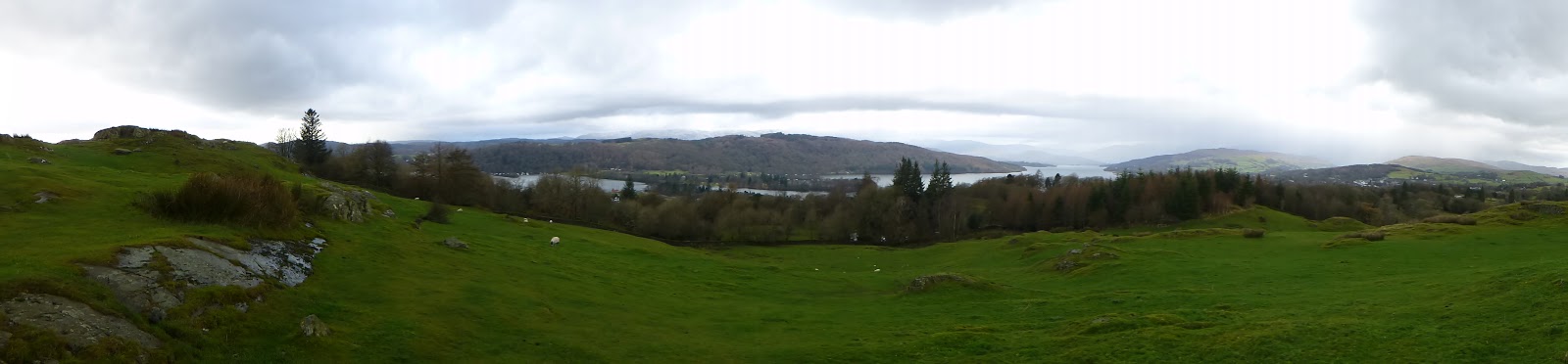
The walk itself is fantastic. It has more ascent than I would have expected for a trail that doesn't really go over much very high ground, just lots of (sometimes very steep) ups and downs. Mainly the path goes through farmland countryside, sheep farming and arable fields. My usual preference for walking is high ground, moorland and fell tops, but I loved Offa's Dyke with its pretty flower-lined lanes and pastures, little towns, old woods,  castles and abbeys, and of course, the dyke itself.


My photographs have now been uploaded - you can see them here - because my new clever little camera has GPS, in each of the galleries clicking on "Map This" will show you where they were taken.


 We stayed here:

Chepstow: The Castle View Hotel
Monmouth: The Punch House (late rooms)
Pandy: Allt Yr Ynys (late rooms)
Hay On Wye: Kilverts
Kington: The Swan
Knighton: The George and Dragon
Mellington: B&B (found from Offas Dyke Association accomodation pages)
Welshpool: The Royal Oak
Llanymynech: The Bradford Arms
Llangollen: Bryn Howel Hotel
Llanferres: The Druid Inn
Bodfari: Glan Clwyd Isa B&B
Prestatyn: The Beaches

Our next challenge is to complete all the 214 Wainwrights before November 23rd 2012, which will mark ten years since we climbed up our first Lakeland fell on our first wedding anniversary - only 23 more to go...